|
|
|
Check these out    Do you have an entertaining or useful blog or personal website? If you'd like to see it listed here, send the URL to leon@pawneerock.org. AnnouncementsGive us your Pawnee Rock news, and we'll spread the word. |
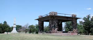
Things to see in Pawnee Rock For an overall view of Pawnee Rock and three counties, climb up the pavilion atop the Rock. Pawnee Rock state parkThis historical park protects a bluff of Dakota sandstone on the north side of town. Hunters and Santa Fe Trail riders used the Rock to find buffalo and enemies. The property became a state park in the early 1900s, and the pavilion was finished in 1920. Today, the outcrop is for sightseeing and picnicking. From here, you can see several towns besides Pawnee Rock: Larned (8 miles southwest), Dundee (5 miles northeast), Great Bend (12 miles northeast), Radium (8 miles southeast as the crow flies or 11 if it's driving) and Seward (13 air miles or 17 road miles). DowntownSome of the old buildings remain from near the start of the 20th century, including the 1908 building (formerly a garage); the 19th-century opera house (at various times the Knights of Pythias hall and a restaurant and now Lee's Antiques); the post office (formerly a bank); the building next to the post office (formerly a tin-ceilinged drugstore); the depot (moved off railroad property); the American Legion hall (formerly grocery stores); and several other old brick buildings. CemeteriesLook for 19th-century graves of American, German, and Russian settlers at the city cemetery, located a half-mile north of town and a quarter-mile west. More Pawnee Rock founders are buried at the Bergthal Mennonite cemetery 2.5 miles north of town on the Township Road, which is on the east side of town. Salt plantIn the mid-20th century, a Cargill salt plant pumped brine out of the ground, dried it in a large drum heated by natural gas and shipped off truckloads and trainloads of pellets for industrial use. The salt plant, now part of a farm, is just west of the cemetery. AntiquesPawnee Rock has an antique store at the intersection of the highway and Centre Street. Older houses provide pleasing architecture. River and bridgesTwo concrete bridges cross the Arkansas River. The Pawnee Rock Bridge is 1.5 miles south and 1.5 east. The O'Rourke Bridge is 1 mile southwest on the highway, then 3.5 south and a short jog east. SchoolPawnee Rock has had at least four school buildings. The only one standing now, at the west end of town, was opened in the mid-1950s. The high school was closed in 1971 and the junior high and grade schools by the mid-1990s. The playground remains, even though the building now houses the city offices. Santa Fe Trail rutsRuts left by wagon trains can be found along Ash Creek, a tributary that feeds the Arkansas River. Ask at the Farmer's Co-op in Pawnee Rock for directions. Closer to town, the trail is remembered as passing between the Rock and where the town now is, although the trail has been plowed over and possibly built on. Between Pawnee Rock and Larned, the trail runs along the flat land at the base of the low hills. |
Sell itAdvertise here to an audience that's already interested in Pawnee Rock: Or tell someone happy birthday. Advertise on PawneeRock.org. |
|
|