|
|
|
Check these out   Do you have an entertaining or useful blog or personal website? If you'd like to see it listed here, send the URL to leon@pawneerock.org. AnnouncementsGive us your Pawnee Rock news, and we'll spread the word. |
Towns near Pawnee Rock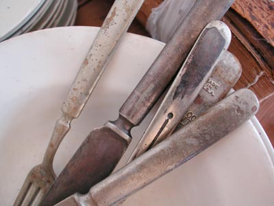 Silverware from the early 1900s survived in many households through the middle part of the century. See more artifacts at the Barton County Historical Museum in Great Bend. The mileages below are close approximations of highway mileage by the most direct route. If you want four-lane roads, your mileage may be much greater. The nearest motels and restaurants are in Larned, 8 miles southwest, and Great Bend, 12 miles northeast. Both are along U.S. 56. EASTDundee, 5 miles NEDundee is a hamlet along a double bend in U.S. 56. A dirt road just east of Dundee leads south to the Arkansas River diversion dam, which -- back in the days when the river always carried water -- redirected some of the flow north and east toward Cheyenne Bottoms. Great Bend, 12 miles NEGreat Bend, pop. 13,000, is the seat of Barton County. Its attractions include the Brit Spaugh park, zoo and swimming pool; Veterans Park, with fishing and rental boats; Cheyenne Bottoms, for waterfowl birding and hunting; the site of Fort Zarah, a short-lived installation from which the Army guarded part of the Santa Fe Trail; and the Barton County Historical Museum, for artifacts and photos of the county's early years. (The church photo at the top of this page is from the museum.) Quivira National Wildlife Refuge, 35 miles EThis marshy area bisected by Rattlesnake Creek has migratory waterfowl, tortoises, deer, songbirds, coyotes and other critters. Ellsworth, 50 NEEllsworth sits at the junction of U.S. 156 and I-70. Nearby in the beautiful-at-sunset Smoky Hills is Kanopolis Reservoir. Lindsborg, 92 miles EAfter you've visited the dala horse shops, the art galleries and the Swedish restaurants, head just northwest of town to ascend the sandstone-block pavilion atop Coronado Heights, named for the Spanish explorer who in the 16th century passed through as he sought the Seven Cities of Gold. Hutchinson, 60 miles SEOmnisphere, state fair and grain elevators. Yoder, 70 miles SEMennonite/Amish cooking. Drive carefully; watch for horse-drawn buggies. Salina, 75 miles NESalina sits at the junction of I-135 and I-70. Wichita, 115 miles SEScience museum, art museum, historical museum, aircraft museum, riverwalk and Wichita State University. Dining, medical care. Wichita has the closest daily jet passenger service. Manhattan, 161 NEKansas State University. You'll see a lot of purple Wildcat emblems around Pawnee Rock. Emporia, 172 miles EEmporia is the home of famed newspaper publisher and progressive Republican leader William Allen White. There's also a nice zoo. Topeka, 200 miles NECapitol, zoo, Kansas state museum. Lawrence, 214 miles NEUniversity of Kansas. Good restaurants and museums, plus a large locomotive on display in a downtown park. Kansas City, 262 miles NEShopping, traffic, medical care, Kansas Speedway, airport. SOUTHMacksville, 24 miles SMacksville is the home of USD 428, which took in many Pawnee Rock students after USD 495 closed Pawnee Rock High School in 1971. This Stafford County town continues to have close ties with Pawnee Rock. Pratt, 80 miles SKansas State Fish and Game aquarium, Miss Kansas Pageant. Greensburg, 60 miles SThe world's largest hand-dug well is here, and the town is rebuilding after the 2007 tornado. Medicine Lodge 110 miles SRemember the saloon-busting prohibitionist Carry Nation? She lived in Medicine Lodge for a while. The town also has a reenactment of a treaty-signing ceremony with the Plains Indians. NORTHAlbert, 11 miles NWAlbert is a farming community with a grain elevator and bank. LaCrosse, 35 miles NWStop in at the Barbed-Wire Museum and the Post-Rock Museum. Russell, 50 miles NRussell is the boyhood home of former Sen. Bob Dole of Kansas and Sen. Arlen Specter of Pennsylvania. This is oil country; you'll notice the derricks along I-70 and U.S. 281. Also, ask around for restaurants with good Czech cooking in Russell and nearby towns, such as Wilson. The Oscar-winning movie "Paper Moon" was filmed in this area. Hays, 60 miles NWHays is the home of a herd of bison and Fort Hays State University. Look for the buildings, especially the soaring churches, made of yellow limestone post rock. The Sternberg Museum of Natural History has a must-see fossil exhibit; it's in the dome along Interstate 70. WESTLarned, 8 miles SWLarned, pop. 4,000, is the seat of Pawnee County. Larned is known for Fort Larned National Historical Site and Larned State Hospital, both just west of town. Pawnee Rock sits right north of the Barton-Pawnee county line, so both Larned and Great Bend are important. Larned is the home of Unified School District 495, which includes Pawnee Rock. Dodge City, 75 miles SWDodge City was once the end of the trail for many cattle driven up from Texas; now the cattle arrive by 18-wheeler from across the region. Attractions include Boot Hill, an amusement area built along the lines of TV's "Gunsmoke." Goodland, 204 miles NWFarm-country museum. Mount Sunflower, 220 miles WDon't let the name fool you. This is rolling farmland and dryland pasture. Along the border with Colorado, Kansas rises to an elevation of 4,039 feet. A picnic table and metal sculptures give the place, on private property, some pizzazz. In fact, these small structures help put the wide-openness of western Kansas in perspective. (Pawnee Rock State Park stands about 2,000 feet above sea level; the town itself is at 1,949 feet.) |
Sell itAdvertise here to an audience that's already interested in Pawnee Rock: Or tell someone happy birthday. Advertise on PawneeRock.org. |
|
|